
Estimating the Volume of Surface Runoff Using a Method (SCS-CN) For the Shahlagha Basin Using Modern Techniques
DOI:
https://doi.org/10.21271/zjhs.29.4.5Keywords:
Hydrologic Soil Groups, Rainfall, Runoff Depth, Runoff VolumeAbstract
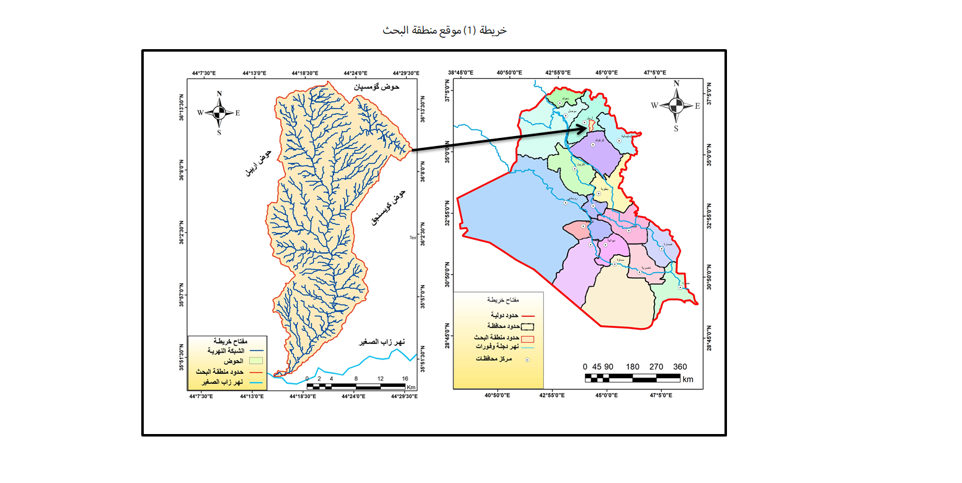
The research aims to estimate the amount of surface runoff in the Shahlagha Basin within Erbil Governorate, which is a seasonal basin with an area of (612) km2, based on rain data and morphometric characteristics of the basin, using estimation equations designed by the US Soil Conservation Service (SCS-CN) to achieve this goal. The value of the numerical coefficient (CN) in the basin was calculated between 71-94, which reflects the diversity of Soil characteristics and land use in the area. Factor (S) values were calculated, which ranged between (5.18-103.75). It was found that the (la) value was less than the median value of 50.8 mm, while the value of (Q) for the research area was During the period from (2014-2023) The maximum depth of flow is (45.085) mm after (50.4) mm of rain fell on 4/12/2023. While the lowest depth of flow was recorded at (12.205) mm after (21.15) mm of rain fell on 12/21/2023.The highest value is for the volume of surface drainage (QV) recorded on 4/2023 and amounted to 52.80618 m3, due to a rainstorm of 50.4 mm. While the lowest value was recorded on 12/21/2023 and was 7.469594 m3 due to 21.15 mm of rainfall. These results form a database of surface drainage in the study area that can be used in investment and sustainable management of the basin.
References
المصادر العربية:
- اقليم كردستان العراق، وزرارة الزراعة والموارد المائية، مديرية زراعة كويه، قسم الانواء الجوية، بيانات المناخية للمدة (2005-2022) غير منشورة.
- الزيدي، اساور رياض وعبد، رحيم حميد، (2021)،تقدير عمق وحجم الجريان السطحي لحوض وادي الكصير باستخدام تقنيات الاستشعار عن بعد ونظم المعلومات الجغرافية، مجلة الدراسات المستدامة ، المجلد الثالثة ، العدد 4، 2021.
- حميد، دلي خلف، 2016، التحليل المكاني لتقدير حجم الجريان السطحي باستخدام(SCS-CN) لحوض وادي المر الجنوبي – شمال العراق، مجلة تكريت للعلوم الصرفة، العدد 21 (5).
- خارطة العراق الادارية،(2004)، وزاراة التخطيط، هيئة المساحة، العراق.
- سامان قادر اسماعيل،2013، المظاهر الجيومورفولوجية لحوض وادي شه لغه وتطبيقاتها، رسالة ماجستير، جامعة صلاح الدين، كلية الاداب،.
- النفعي، محمد النفيعي (2010، تقدير الجريان السطحي ومخاطرة السيلية في الحوض الأعلى لوادي عرفة شرق مكة المكرمة بوسائل الاستشعار عن بعد ونظم المعلومات الجغرافية، رسالة ماجستير، جامعة أم القرى، كلية العلوم الاجتماعية، قسم الجغرافية، 2010.
- المصادر الانكليزية:
- AL-Gamdi، S (1991)، Estimating Runoff Curve Numbers of the Soil Conservation Service in Arid and Semi-arid Environments Using Remotely Sensed Data، A dissertation Submitted to the Faculty of the University of Utah, USA,p.25.
- Esri Inc. (2021, July). land use/land cover [Data set]. Universal Transverse Mercator (UTM) projection, WGS84 mosaic projection, global extent, Sentinel-2 source imagery, 10m cell size, thematic type. Esri Inc.
- Ibtesam R.Kareem(2015) Conjunctive Use Modeling of Surface Water and Croundwater in The Jolak basin, North Iraq. University of Technology, Journal of Kerbala University, 13 (1), p.239.
- Soulis, K. X.and Valiantzas, J. D. (2012) SCS –CN parameter determination using rainfall- runoff data in heterogeneous watersheds- the two- CN system approach. Hydroligy and Earth System Sciences, 16, pp1001-1015
- Soil Conservation Service (1986) Urban Hydrology for Small Watershed. Technical releases 55, 2nd ed.U.S. Dept. of Agriculture, WashingtonD.C.
- Taylor, C.H.and Francis, F.J. (1982) The antecedent soil moisture condition of the curne number procedure.
- Hydrological Sciences Journal, 27 (3), p.5.
- Vijay p. Singh, and Donald K. Frevert, (2006) Watershed Models, CRC press is an imprint of Taylor& Francis Group,p.364
Downloads
Published
How to Cite
Issue
Section
License
Copyright (c) 2025 Aso Swar Namiq

This work is licensed under a Creative Commons Attribution 4.0 International License.


