The Role of Geomorphological Factor on The Urban Expansion of Both Shaqlawa and Soran cities –A comparative study in Urban Geomorphology
##semicolon##
https://doi.org/10.21271/zjhs.27.6.11##semicolon##
Urban geomorphology##common.commaListSeparator## Urban expansion##common.commaListSeparator## Geomorphological factors##common.commaListSeparator## Saqlawa city##common.commaListSeparator## Soran cityپوختە
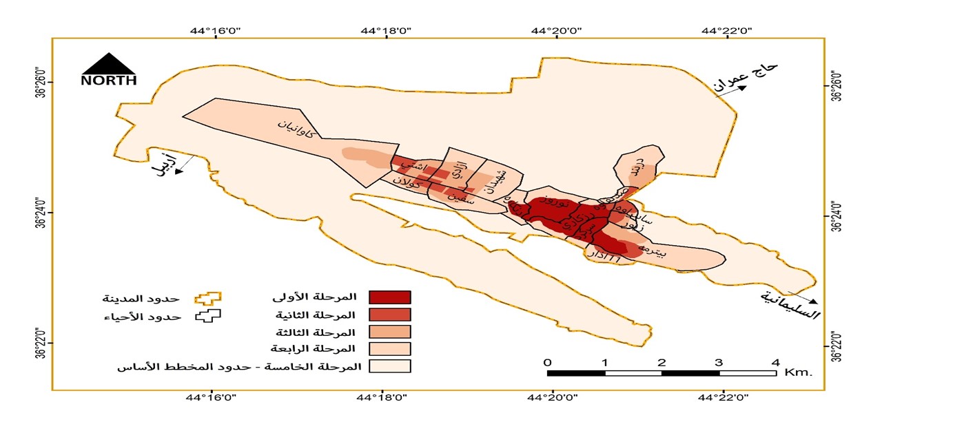
This paper is an investigation into the joint influence of geomorphology and urban geography in urban geomorphology. The importance of the paper stems from the fact that the correctness or incorrectness of the choice in directing the expansion of cities has positive or negative effects and consequences on both the population and the government. Methods, the urban evolution of the two cities, and the results and discussion are the three primary sections of this paper, which aims to determine the extent to which the expansion of the mountain cities of Shaqlawa and Soran takes into account the geomorphological factor. The paper concluded that, in the absence of government involvement, the population's choices have always gone towards the most optimal areas for the safety of buildings and houses, by selecting the Shiranish and Tanjero formations in both cities. Also, due to the impact of tourism investments, geomorphological variables have a part even in irrational choices to move to the heights of the mountains, like in Shaqlawa.
سەرچاوەکان
المصادر الكوردية:
-الحداد، هاشم یاسین حمدامین & محمود، كامران ولي (2011)، ئهتڵهسی پارێزگای ههولێر، چاپخانهی شههاب، ههولێر
-مولود، هۆزان صادق (2018)، كاریگهریی شێوهكانی رووی زهوی لهسهر فراوانبوونی شاری شهقڵاوه به بهكارهێنانی ههستكردن لهدوورو GIS، گۆڤاری ئهكادیمیای كوردی، (41)، ههولێر، ل413-436
المصادر العربية:
-أحمد، ديار محمد (2014)، تحليل وتخطيط الخدمات المجتمعية في مدينة شقلاوة – دراسة في جغرافية الخدمات، رسالة ماجستير (غير منشورة)، كلية الآداب، جامعة صلاح الدين – أربيل
-الأمم المتحدة، برنامج العذاء العالمي – WPF (2019)، أطلس العراق الاقتصادي الاجتماعي
-الجابري، مظفر علي (1986)، التخطيط الحضري-مدخل عام، ج1، جامعة بغداد
-جمعة، مازن عبدالرحمن & العاني، صلاح عثمان عبد (2021)، أثر الطبوغرافية في نشأة ونمو وتطور مدينة هيت – دراسة في الجيومورفولوجيا الحضرية باعتماد التقنيات الحديثة، مجلة جامعة تكريت للعلوم الإنسانية، 28 (3)، ص67-51
-الجمهورية العراقية، وزارة التخطيط، الجهاز المركزي للإحصاء (1988)، نتائج التعداد العام للسكان لعام 1987 – محافظة أربيل، مطبعة الجهاز المركزي للإحصاء، بغداد
-الجمهورية العراقية، وزارة الداخلية (1963)، المجموعة الإحصائية لتسجيل عام 1957 – لوائي الموصل وأربيل، مطبعة الأرشاد، بغداد
-الحسن، محمد الحسين محمد (2021)، الجيومورفولوجيا الحضرية وأثرها في تغير استخدامات الأرض بمدينة أسوان باستخدام تقنية نظم المعلوماتالجغرافية والاستشعار عن بعد، مجلة كلية الآداب بقنا، جامعة جنوب الوادي، (53)، (الجزء الأول)، ص1953-2032
-حكومة إقليم كودرستان - العراق، وزارة البلدية والسياحة (2004)، المديرية العامة للتخطيط العمراني، قسم التصميم الأساسي، خارطة التصميم الأساسي لمدينة سوران لغاية عام 2035
-حكومة إقليم كودرستان - العراق، وزارة البلدية والسياحة (2012)، المديرية العامة للتخطيط العمراني، قسم التصميم الأساسي، خارطة التصميم الأساسي لمدينة شقلاوة لغاية عام 2035
-حكومة إقليم كوردستان – العراق، وزارة التخطيط، دائرة إحصاء أربيل (2022)، بيانات سكان محافظة أربيل لعام 2020 بحسب النواحي والبيئة، أربيل
-حكومة إقليم كوردستان – العراق، وزارة الداخلية، اللجنة العليا لاستقبال اللاجئين (2009)، سجلات العائدين من دولة إيران للفترة 1991 – 2004، سوران (غير منشورة)
-حكومة إقليم كوردستان – العراق، وزارة الداخلية، قائمقامية قضاء سوران (2008)، قسم الذاتية، بيانات عن سكان قضاء الصديق في عام 1980 (غير منشورة)
-الحموي، شهاب الدين أبي عبدالله ياقوت بن عبدالله (1977)، معجم البلدان – المجلد الثالث، دار صادر، بيروت
-الدليمي، يونس هندي عليوي (2018)، الجيومورفولوجيا الحضرية ودورها في تطور المراحل المورفولوجية لمدينة القائم – دراسة مقارنة منذ النشأة حتى 2017 باستخدام نظم المعلومات الجغرافية ArcMap، المجلة العراقية لدراسات الصحراء، 8 (2)، ص176-184
-الشمري، مسلم كاظم حميد (2006)، التحليل المكانى للتوسع والامتداد الحضري للمراكز الحضرية الرئيسة في محافظة ديإلى، أطروحة دكتوراه (غير منشورة)، كلية التربية-إبن رشد، جامعة بغداد
-الشمري، هيثم عبدالحسين علي، وإسماعيل، نبيل طه، وحمزة، شيماء مطشر (2019)، الانتشار الحضري سمة المدن العربية – مدينة الرياض وبغداد انموذجاً، مجلة الهندسة والتنمية المستدامة، المجلد23، العدد1، ص39-57
-العزاوي، نبيل قادر بكر (1982)، دراسة مقارنة في الطراز التكتوني للطيات لثلاث مناطق من قطاع الطيات البسيطة في العراق، رسالة ماجستير (غير منشورة)، كلية العلوم، جامعة الموصل، الموصل
-عطوي، عبدالله (2001)، جغرافية المدن، الجزء الأول، مطبعة دار النهضة العربية، بيروت
-قهرمان، ليلى محمد (2004)، التحليل الجغرافي لخصائص و مشاكل ترب محافظة اربيل، أطروحة دكتوراه (غير منشورة)، كلية الآداب، جامعة صلاح الدين، أربيل
-الكبيسي، أمجد رحيم محمد (2020)، الجيومورفولوجيا الحضرية وأثرها في توزيع استعمالات الأرض في مدينة الحقلانية، مجلة الأستاذ للعلوم الإنسانية والاجتماعية، 59 (4)، ص203-226
-محمد، خليل اسماعيل (2005)، دهوك – نينوى، دراسات في الخصائص الديموغرافية للسكان، مركز كوردستان للدراسات الستراتيجية، السليمانية
-محمود، كامران ولي & عبدالله، ساكار بهاء الدين (2017)، أقليم الوظيفة التجارية لمدينة سوران – دراسة تطبيقية في جغرافية المدن، مجلة الأكاديمية الكردية، (79)، أربيل، ص493-544
-محمود، كامران ولي (2017)، نمذجة التوسع الحضري لمدينة سوران باستخدام نظم المعلومات الجعرافية، مجلة زانكو للعلوم الإنسانية، 20 (1)، ص148-166
-محمود، كامران ولي (2018)، التحليل الجغرافي لخصائص أقليم الوظيفة الجامعية للمدن – مدينة سوران / محافظة أربيل نموذجا، مجلة تويژهر، 1 (1)، سوران، ص466-510
-المملكة العراقية، وزارة الشؤون الاجتماعية، مديرية النفوس العامة (1954)، إحصاء السكان لسنة 1947، الجزء الثاني، لواء (الموصل، كركوك، السليمانية، أربيل)، بغداد
المصادر الإنجليزية:
-Almeida, B. (2005), A GIS Assessment of Urban Sprawl in Richmond, Virginia, A Master thesis submitted to the council of the faculty of Virginia Polytechnic Institute and State University
-Al-Qayim, B. A., Al-Daghstany, H. S., & Bety, A. K. (2019). Gis-Based Urban Geomorphological Analysis of the Sulaimania City, Kurdistan Region, NE IRAQ. Iraqi Bulletin of Geology and Mining, 15 (2), pp. 71-89
-Ami, H. M. (1891), On the geology of Quebec and environs, Geological Society of America Bulletin, (2), pp. 477-500
-Ami, H. M. (1892), Additional notes on the geology and paleontology of Ottawa and its environs, Ottawa Naturalist, (6), pp. 73-78
-Ami, H. M. (1897), Synopsis of the geology of Montreal, British Medical Association Guide and Souvenir, pp. 45-49
-Ami, H. M. (1900), On the geology of the principal cities in eastern Canada, Royal Society of Canada Proceedings and Transactions, (2) 6, 4, pp. 125-173
-Ami, H. M. (885), Additional notes on the geology and paleontology of Ottawa and vicinity, Ottawa Field Naturalists Club Transactions, (6), pp.251-259
-Bathrellos, G. D. (2007), An overview in urban geology and urban geomorphology, Bulletin of the Geological Society of Greece, (40), proceedings of the 11th International Congress, Athens
-Cappadonia, C., Di Maggio, C., Agate, M., & Agnesi, V. (2020). Geomorphology of the urban area of Palermo (Italy). Journal of Maps, 16 (2), pp. 274-284
-Coates, D. R. (Ed.). (1976). Urban geomorphology (Vol. 174). Geological Society of America
-Dataset: ©JAXA/METI ALOS PALSAR (Digital Elevation Model 12.5 m.), Accessed online through ASF DAAC (https://asf.alaska.edu) in [Oct 2022]
-Gregory, K. J. & Lewin, J. (2014), The Basics of Geomorphology Key Concepts, 1st edition, SAGE Publications Ltd, London
-Hassan A., Almatar M., Torab M. & Allen C. (2020), Environmental Urban Plan for Failaka Island, Kuwait: A Study in Urban Geomorphology, Journal of Sustainability, 12 (7125), pp. 1-21
-Jassim, S. Z. & Sissakian, V. K. (1978), Field Guid to the Geology of Salah Al-din- Shaqlawa Area, North Eastern Iraq, Field Excursion Guide, 5th Iraqi Congress, Baghdad, p.28
-Jeong, A., Cheung, S. Y., Walker, I. J., & Dorn, R. I. (2018), Urban geomorphology of an arid city: Case study of Phoenix, Arizona. In Urban geomorphology (pp. 177-204). Elsevier
-Moradipour, F., Moghimi, E., Beglou, M. J., & Yamani, M. (2020), Assessment of urban geomorphological heritage for urban geo-tourism development in Khorramabad City, Iran. Geoheritage, 12 (2), 1-20
-Salar, S. G. (2017). Urban Geomorphology of Darbandikhan District Using GIS & RS Iraqi Kurdistan Region. Journal of Garmian University, (4) (ICBS Conference), pp. 301-319
-Sissakian, V. K. & R. Youkhana (1984), The Study of Upper Most Part of Qamchuqa Formation at Shaqlawa Vicinity, North Iraq, Jour. Geol. Soc. Iraq, 16-17, p.2
-Sissakian, V. K. (1997), GEOLOGICAL MAP OF ARBIL AND MAHABAD QUADRANGLES, SHEETS NJ-38-14 and NJ-38-15, Scale 1:250000, Baghdad
-Skilodimou, H., Livaditis, G., Bathrellos, G., & Verikiou‐Papaspiridakou, E. (2003), Investigating the flooding events of the urban regions of Glyfada and Voula, Attica, Greece: a contribution to Urban Geomorphology. Geografiska Annaler: Series A, Physical Geography, 85 (2), pp. 197-204
-Thornbush, M. (2015), Geography, urban geomorphology and sustainability, Journal of Area, 47 (1), pp. 350-353.
-Wilmshurst, David (2000), The Ecclesiastical Organisation of the Church of the East, 1318-1913, (5), Peeters Publishers
-Youkhana, R. & Sissakian, V. K. (1986), Stratigraphy of Shaqlawa-Quwaisanjaq Area, Jour. Geol.Soc. Iraq, 19 (3), p.142

##submission.downloads##
بڵاو کرایەوە
چۆنییەتی بەکارهێنانی سەرچاوە
ژمارە
بەش
##submission.license##
##submission.copyrightStatement##
##submission.license.cc.by-nc-sa4.footer##Except where otherwise noted, content on this site is licenced
under a Creative Commons Attribution License 4.0 (CC BY- 4.0)


