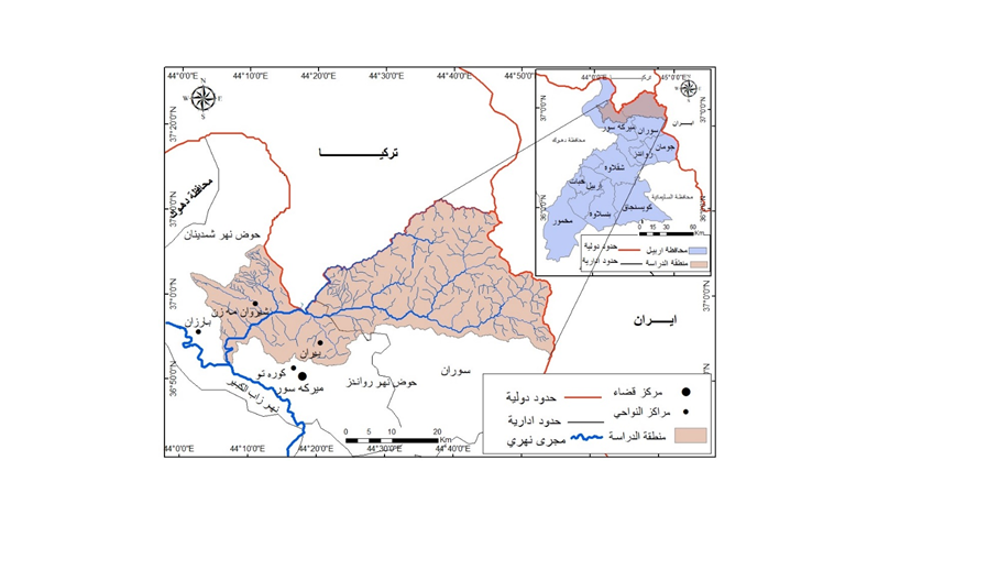
Estimating the Volume of Water Torrents in the Rizan River Basin and its Environmental Risks
DOI:
https://doi.org/10.21271/zjhs.28.SpC.10Keywords:
Runoff, Rizan Basin, Environmental risksAbstract
This study aims to determine the basic hydrological characteristics in the Rezan River Basin and their role in the occurrence of torrential and flood risks and to determine the most important effects that torrents and floods leave on the nature of the region and human activities in it. The inductive approach and statistical method were used to trace the precise parts of the topic to reach general conclusions. The US Soil Service model (SCS-CN) method was adopted to estimate the volume of surface runoff using a program (WMS). The model (SCS-CN) was applied ten times using rain showers ranging from (20-200 mm), with a difference of (20 mm), in addition to a real rain peak.
The study found that the depth of surface runoff in the study area increases with the increase in the amount of precipitation. it’s reached (52.6) mm in the Haji-Bag Basin, and (45.2) mm in the Baraz-ger basin, At the rain peak recorded at Mergasur station, amounting to (176.5) mm. The flow volume in the Haji-Bag basin (16654320) m3 and in the Baraz-ger basin (51241607.2) m3. The study showed that water torrents in the Rezan River Basin cause a lot of damage to elements of the natural and human environment.
References
-امين، شمال احمد ، اسماعيل، دلوفان رمضان ، (2022) ، تقدير حجم التعرية و اتلرسيب في حوض وادي بيداوة باستخدام نموذج (GCD) دراسة في الجيومورفولوجيا التطبيقية.
-امين، شمال احمد ، اسماعيل، دلوفان رمضان ، (2022) ، تقدير حجم التعرية و اتلرسيب في حوض وادي بيداوة باستخدام نموذج (GCD) دراسة في الجيومورفولوجيا التطبيقية.
-خضر، صهيب حسن، (2021)، تقييم نخاطر الفيضان لحوض كارديم حسب طريقة تحليل متعدد المتغيرات ، جامعة موصل ، قسم الجغرافيا ، كلية التربية للعلوم الانسانية.
- الشبلاف، محمد ، (1995) الهيدرولوجيا، جامعة دمشق، دمشق.
- الكناني، حيدر محمد حسن ، (1986) تقدير عمق الجريان السطحي لحوض وادي ابو غار باستخدام تقنيات الاستشعار عن بعد و نظم المعلومات الجغرافية.
-النفيعي، هيفاء محمد ، (2010)، تقدير الجريان السطحي ومخاطره في الحوض الأعلى لوادي عرنة شرقي مكة المكرمة بوسائل الاستشعارعن بعد ونظم المعلومات الجغرافية، رسالة ماجستير، جامعة ام القرى، كلية العلوم الاجتماعية، المملكة العربية السعودية,
-خضر، صهيب حسن ، (2021)، تقييم نخاطر الفيضان لحوض كارديم حسب طريقة تحليل متعدد المتغيرات ، جامعة موصل، قسم الجغرافيا ، كلية التربية للعلوم الانسانية.
- محمود، محمود عبدالرحمن ، (2002)، خريطة مخاطر الفيضانات و السيول في مدينة الرياض ، نموذج محاكاة باستخدام نظم المعلومات الجغرافية.
-عبدالماجد، عصام محمد ، إبراهيم، عباس عبدالله، (2002)، الهيدرولوجيا، دار جامعة سودان للنشر والطباعة، ط 1.
- فريج، مجيب رزوقي ، (2018)، التقيم الهيدرولوجي للاحواض جنوب شرق بيرس واثارها على التنمية المستدامة، أطروحة دكتوراه.
-سعد، كاظم شنته ، حسن، محمد وحيد، (2019)، تقدير حجم السيول المائية لوادي لوبيتر شمال شرق محافظة ميسان وأثارها البيئية، مجلة الفنون والادب وعلوم الانسانيات والاجتماع، العدد (41).
قائمة المصادر الانكليزية
-Chov, V. T, Maidment D.R, and mays L.W, (1986)” Applied Hydrology” mcbraw-Hill, New York, USA.
-USDA – SCS, Urban hydrology for small watershed, department of agriculture, USA, 1986.
-Richard C. sorrel, P.E 2010, computing flood Discharge for small ungagged watershed, Michigan Department of natural Resources and Environment land and water management Division June 22.
-P. Singh. “Validity and extension of the SCS-CN method for computing in flirtation and rainfall – excess rates, “Hydrological processes 17.18 ج2004.
- Soil conservation service, urban Hydrology, for small watershed, technical releases 55, and Ed, u.s. Dept. of Agriculture, Washington D.C. 1986.
-Taher, T.M.Integration of GIS data base and scs – cn method to estimate runoff volume of wadis of intermittent flow. Arabian Journal for science and Engineering. 1985.
-www.chiefscientist.qld.gov.au,12-6-2018 Retrieved 1-4-2019. Edited KenRubin, Environmental Effects of Floods"،

Downloads
Published
Issue
Section
License
Copyright (c) 2024 Halaw Hussain Karem , Nzar Yasin Muhammad

This work is licensed under a Creative Commons Attribution 4.0 International License.


