
Spatial Variation of Hypsometric Analysis in Nerwa Watershed
DOI:
https://doi.org/10.21271/zjhs.28.1.2Keywords:
Hypsometry curve, Hypsometry integral, Watersheds, Spatial Statistic analysis.Abstract
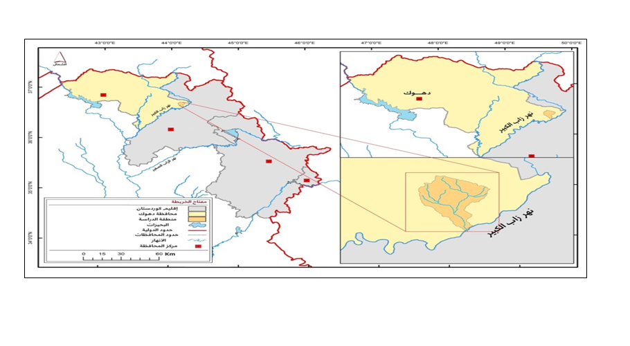
The hypsometric analysis (area-relief analysis) of drainage basins is an effective method for measuring the percentage of subsurface materials remaining in watersheds and highlighting the influence of slope leveling factors on them. This study aims to highlight the spatial variation of the values of the hypometric curve and hypsometry integral in the Nirwa basin and its sub-watersheds, and to detect the correlation and the influence degree between the values and the factors influencing them, The importance of the study lies in the fact that it discusses the results of applying mathematical equations to account the values of the hypsometric analysis that indicate the percentage of remaining land masses and the general topographical characteristics of the basin and their exposure to erosion factors, indicating the results in percentage and supported by a graph. The investigation concluded that the Wadi Nirwa watershed was in the late stage of the erosion cycle, and that more than two-thirds of the rock masses were removed in the watershed, as the values of its hypsometric integral reached 0.32%, and that the common category of hypsometric integral is 0.35-0.6%, as the values of 21 sub-watersheds ranged between 0.34-0.58%. The study also showed that the topographic characteristics are among the most influencing properties on the spatial variation of the hipsometric analysis values, and that the best model that can explain these variations is the model that consists of the variables of mean elevation, relative relief, slope average and dissection index.
References
- جمعة، م. د., تطبيقات إحصائية ومكانية متقدمة, القاهرة, مصر, 2018.
- مولود, هوزان صادق, تحليل جيمورفولوجي لتقدير التعرية المائية في الأحواض الجنوبية الغربية لجبل أكري, أطروحة دكتورا مقدمة إلى كلية الأداب- أربيل, أربيل, 2022.
- Cavalli, M., and Trevisani S., "Hypsometric analysis of headwater rock basins in the Dolomites (Eastern Alps) using high- resolution topography", Geografika Annaler, Series A, Physical geograpgy, 97, pp. 317- 335.
- Chorley, Richard J. and Morley, L. S. 1959. “ A Simplified approximation for the Hypsometric integral.”, The Journal of Geology, Vol. 67, No. 5, pp. 566-571.
- Gregory, K.J. and Walling, D.E., Drainage Basin Form and Process A Geomorphological approach, London, Edward Arnold, 1973.
- Horton R. E., "Erosional development of streams and their drainage basins Hydrological approach to quantitative morphology", Geol, Sco. bull., Vol 56, 1945..
- Hurtrez J., and Lucazaeu, F., "Investigation of the relationships between basin morphology, tectonic uplift, and denudation from the study of an active fold belt in the Siwalik Hills, central Nepal", Journal of Geographical, Research, Vol. 104, No. B6, 1999, pp. 12779- 12796.
- Keller, E., and Pinter, N., "Active Tectonics: Earthquakes, Uplift, and Landscape", NY, 2nd ed, Prentice Hall, 2002.
- Marchi, L., Cavalli M. and Trevisani S., "Hypsometric analysis of headwater rock basins in the Dolomites (Eastern Alps) using high‐resolution topography", Geografiska Annaler. Series A, Physical Geography, Vol. 97, No. 2, 2015, pp. 317-335.
- Melton M.,"Correlation Structure of Morphometric Properties of Drainage Systems and Their Controlling Agents", The Journal of Geology, Vol. 66, No. 4 1958, pp. 442-460.
- Perez Pena J.,, Azanon, J., Booth- Rea, G, Azor A., and Delgado J., "Differentiating geology and tectonics using a spatial autocorrelation technique for the hypsometric integral" Journal of Geographical Research, Vol. 114, 2009.
- Pike R, Wilson S., "Elevation-relief ratio, hypsometric integral, and geomorphic area-altitude analysis.", Geol Soc Bull., Vol. 82, 1971, pp.1079–1084.
- Schumm, S. A. 1956 “Evolution of Drainage Systems and Slopes in Badlands of Perth Amboy.”, Bull. Geol. Soc., Vol. 67, pp. 597- 646.
- Schumm, S. A., "Evolution of Drainage Systems and Slopes in Badlands of Perth Amboy, New Jersey". Bull. Geol. Soc., Vol. 67, 1956.
- Strahler A. N., "Hypsometric (area–altitude) analysis of erosional topography", Bull. Geol. Soc., Vol. 63, 1952, pp.1117–1141.
- Willgoose, G., and Hancock, G., "Revisiting the hypsometric curve as an indicator of form and process in transport‐limited catchment", Earth Surf. Process. Landforms 23, 1998.
Downloads
Published
How to Cite
Issue
Section
License
Copyright (c) 2024 Hozan Sadiq Mawlood

This work is licensed under a Creative Commons Attribution 4.0 International License.


