
Characteristics of the River Islands of the Greater Zab River Between "Rizan Village and Its Mouth" Hydro Geomorphological Study
DOI:
https://doi.org/10.21271/zjhs.28.SpA.2Keywords:
Great River, River, Island.Abstract
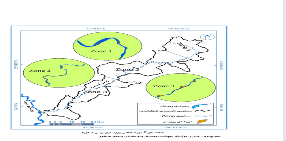
This study was conducted on the Great River between Rezan village and its mouth with the aim of determining the characteristics of the river islands, based on satellite images (Landsat 8) using the index Modified Normalized Water Difference (MNDWI). Then compare the map of the area in Google Earth Map History to ensure the presence of river islands and their locations, then use field work and camera images (FlyCam) to investigate the number of islands. The number of river islands in the region reaches (84) permanent islands, and based on different classifications. have been presented. Most of the islands are located in the middle of the river corridor, which has 38 islands. Most of the islands are in the middle of the river corridor, which has 64 islands. In the same way, in terms of the place of creation of the islands. Meanwhile, according to the island surfaces, it has been found that 64 rivers belong to the small areas, and their areas are between 284-80,539 m2.
References
- Abbas Muneer A. and et al.,"Amorphometric Study of River Islands on the Euphrates River between Jurf al-Nasr and Saddat alhindyya districts using Geographic information systems and Remote sensing" Journal of Jilin University, vol 40, 2021.
- Clyton, K. M., "Slopes", Oliver and Boyd, Edinburgh, 1972.
- Jeffre peakall، "The Influences of Lateral Ground-Tilting on Channel Morphology and Alluvial Architecture”. ، phd, Earth Sciences and School of Geography, University of Leeds,1995.
- Ro Charlton., "Fundamentals of fluvial geomorphology ", New york, Routledge, 2008.
- Strahler, A.N. "Physical Geography", 2Ed, London, 1960.
- Thornthwaite, C. W., "The Climates of North America according to a New Classification", Geographical Review, Vol. 21, No. 4, 1931.
- Varoujan K. S., "Geomorphology and morphometry of the Greater Zab River Basin, North Iraq", Iraqi Bulletin of Geology and Mining, Vol.9, No.3, 2013.
- .xu, Hanqiu, Modification of normalised difference water index (NDWI) to enhance open water features in remotely sensed imagery, International Journal of Remote Sensing 27, No. 14, 2006.
- أسود، فلاح شاكر، "الخرائط الموضوعية"، دار الكتب للطباعة والنشر، جامعة موصل، موصل، 1991.
- الخليفاوي، خالد مرزوك رسن.، "جزر نهر الفرات في العراق (دراسة جيومورفية) "، اطروحة دكتوراه، كلية التربية، الجامعة المستنصرية، 2008 (غير منشورة).
- الشمري، أياد عبد علي سلمان.، "جيومورفولوجية الجزر النهرية في نهر دجلة بين الدبوني وسدة الكوت"، رسالة ماجستير، كلية الآداب، جامعة بغداد، 2008، (غير منشورة).
- حكومهتی ههرێمی كوردستان، بهڕێوهبهرایهتی گشتی سهرچاوهكانی ئاو، هۆبهی (GIS)، نهخشهی قهزاكانی پارێزگای ههولێر، 2020.
- حكومهتی ههرێمی كوردستان، وهزارهتی كشتوكاڵ وسهرچاوهكانی ئاوی پارێزگای ههولێر، هۆبهی ئامار، داتاكانی پلهی گهرمی وباران بۆ ساڵانی (2000 – 2020).
- حكومهتی ههرێمی كوردستان، بهڕێوهبهرایهتی گشتی سهرچاوهكانی ئاو، هۆبهی (GIS)، داتا به شێوهی (Shape file) تایبهت به حهوزهكانی ڕووبار له ههرێمی كوردستان، 2020.
- حكومهتی ههرێمی كوردستان، وهزارهتی كشتوكاڵ وسهرچاوهكانی ئاوی پارێزگای ههولێر، هۆبهی ئامار، داتاكانی تایبهت به لهبهر ڕۆیشتنی ڕووبارهكانی ههرێمی كوردستان.
Downloads
Published
How to Cite
Issue
Section
License
Copyright (c) 2024 Kawa Jabbar Rahman, Tahseen Abdulraheem Azeez

This work is licensed under a Creative Commons Attribution 4.0 International License.


