
Geomorphology of Gali Ali Beg Valley Area in Erbil Governorate
DOI:
https://doi.org/10.21271/zjhs.28.3.7Keywords:
geomorphological landforms, Gali Ali beg, geology, geomorphological hazards, faults, Erbil Governorate, slope, erosionAbstract
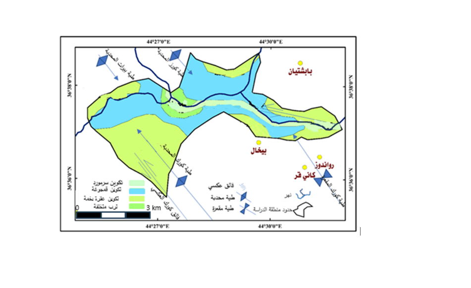
Due to the importance of the study area for Erbil governorate and for it is practical and strategic implications, as it represents the only pass way that passes a high and complex structural ranges that linked the north part of the governorate with middle and south parts, and also for it is tourism importance and scientific value for the geologic purposes in particular, as it reveals rock formations at great depths in the valley area and for the lack of paying attention to this area from scientific point of view due to scarcity of geological and geomorphological studies about it, so the study aimed to study the landforms, perhaps its data and analyses contribute to development plans and projects that may include the study area in the future, as well as developing solutions for the geomorphological hazards taking places in the study area such as mass movements which are threatening architectures foundations, facilities and also people there. The main objectives of this study are to simplify and clarify the complex view about the area for the researchers and those interested in the field of geomorphology and other related disciplines, though the study found out the valley area is highly affected by its structural status. That represented by many folds which are subjected to main and giant faults; therefore, the structural factor was the dominants agents in developing most of the landforms in the area such steep slopes and landforms caused by mass movements, waterfalls, springs and the gorges …. etc., and also there is some geomorphic hazards in which some solutions have been proposed for.
References
المصادر العربية:
-الخلف، جاسم. محمد. (1959). محاضرات في جغرافية العراق الطبيعية- الاقتصادية- البشرية (1st ed.). مطبعة المعرفة، ص84.
-الدليمي, خلف. حسين. (2012). علم شكل الارض التطبيقي (الجيومورفولوجيا التطبيقية) (1st ed.). دار صفاء للطباعة والنشر والتوزيع، ص 408.
-الراوي, عادل. سعيد., & السامرائي، قصي. مجيد. (1990). المناخ التطبيقي. مطبعة دار الحكمة للطباعة والنشر، ص 114.
-قادر، رێژین. اکرم. (2012). أثر الجفاف على المياه الجوفية في محافظة اربيل. رسالة ماجستير غير منشورة (الملحق رقم 2).
-شلش، ع.، حديد، أ.، & ولي، م. (1987). جغرافية الاقاليم المناخي. مطبعة جامعة صلاح الدين. ص 273-274.
-الفيشاوي، م. (2004). دول الآسيان العشر عالم سياحي عجيب. مجلة السياحة الاسلامية، العدد 13، مؤسسة جوزيف د. الرعيدي للطباعة، ص53-55.
-کربل، عبدالاله رزوقی. (1986). علم الاشكال الارضية (الجيومورفولوجي). جامعة البصرة، ص26.
-المصادر الانجليزية:
-Abtahi, M., Saif, A., & Khosroshahi, M. (2012). Investigation of the last Quaternary climate from the geomorphic evidence in Namak Lake basin, Central Iran. Journal of Geography and Regional Planning, 5(3), 93.
-Chepil, W. S. (1962). Climatic factor for estimating wind erodibility of farm fields. Journal of Soil and Water Conservation, 17(4), 162-165
-Gong, J., & Gerken, L. (2003). GIS in an overview of Iraq petroleum geology. Search and Discovery, 10041, 1-15.
- Hamilton, A. M., & Rowan-Robinson, H. (1937). Road through Kurdistan: The narrative of an engineer in Iraq, London.
-Hassan, K. F. (2011). CLIMATIC INTERACTION EFFECTS OF RAIN AND WIND ON SOIL EROSION IN ARID AND SEMI-ARID REGIONS. Journal of Tikrit University for Agricultural, 11(3)., p 334.
-Hungr, O., Leroueil, S., & Picarelli, L. (2014). The Varnes classification of landslide types, an update. Landslides, 11, 167-194.
- (n.d.). Advanced Spaceborne Thermal Emission and Reflection Radiometer: ASTER. Retrieved October 3, 2023, from http://www.asterweb.jpl.nasa.gov
- Jassim, S. Z., & Goff, J. C. (Eds.). (2006). Geology of Iraq, 1st edition, published by DOLIN, sro, distributed by Geological Society of London.
- Omar, A. A., & Othman, A. T. (2018). Morpho-structural study of the Korek Anticline, Zagros fold-thrust belt, Kurdistan of Iraq. Geotectonic, 52(3), 382-400, p 56.
- SISSAKIAN, V. (1998). THE GEOLOGY OF ERBIL AND MAHABAD QUADRANGLES SHEET NO. NJ-38-14 & NJ-38-15 GM5&6. No 2462.
- Sissakian, V., & Youkhana, R. (1983). The study of upper most part of Qamchuqa Formation at Shaqlawa vicinity, North Iraq,p.2.
-SKAARUP & JESPERSEN Architects and Planners. (1980). Tourism Development (Gali Ali Beg & Bekhal) (Vol. 2). Planning, Group for planning, Architectures and Development Research.
- Smith, D. I., & Stopp, P. (1978). The river basin: an introduction to the study of hydrology. Cambridge University Press, p333.
- Thornthwaite, C. W. (1931). The climates of North America: according to a new classification. Geographical review, 21(4), 633-655.
- Youkhana, R., & Sissakian, V. (1986). Stratigraphy of Shaqlawa-Koisanjaq area. Journal of the Geological Society of Iraq, 19(3), 137-154.
- Young, A. (1972). Slopes: Edinburgh. Oliver and Boyd, 288.
Downloads
Published
How to Cite
Issue
Section
License
Copyright (c) 2024 Hikmat Abdulazeez Hamad Alhusainy

This work is licensed under a Creative Commons Attribution 4.0 International License.


